New Game Weekend: The Battle Of Bushy Run

BushyRunMap

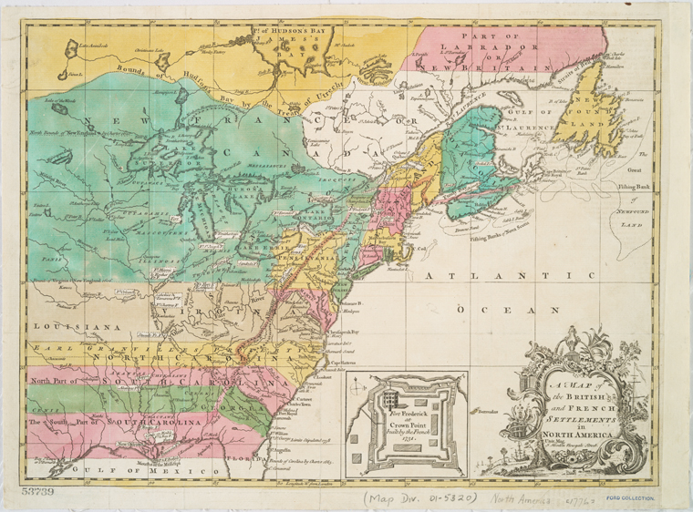
The end of the French and Indian War in 1763 was less than satisfactory for many of the participants, especially the Native American tribes which had been entwined in decades of alliances with British and French forces. After losing their attachment to their longtime French allies in the Great Lakes Region, many Indian tribes were angered by the post-war British policies which aggressive opened white settlement to the Ohio Territory (present day Western Pennsylvania and Ohio), Illinois Country (portions of present day Illinois, Indiana and Michigan) and wider Great Lakes Region (including present day Western New York). British promises to continue the flow of gifts to the tribes in the region were also cut back, further angering the Native peoples who had become dependent on European trade goods over the years.

Feeling duped by British colonial rule, a confederation of more than a dozen tribes rose up in a unified force led by Ottawa leader Pontiac (among other tribal leaders in the region). In the spring of 1763, groups of white settlers and multiple British forts and in the disputed territories were attacked. After the destruction of several smaller forts and an unsuccessful siege at Fort Detroit, another at Fort Pitt also occurred. With a British relief column en route from the east, many of the Indians at Fort Pitt broke off to the meet the British. What resulted was the Battle of Bushy Run on August 5-6, 1763.

IMG_6397MMP’s Special Ops Issue #5 from September 2014

Multi-Man Publishing is best known for it’s 20th-century wargames (including the classic Advanced Squad Leader), but the September 2014 issue of their Special Ops magazine contains a nifty little game for the Battle of Bushy Run. Packed into just four pages of rules, 88 cardboard counters and two beautiful maps, MMP’s presentation of the two-day battle in the thick woods of Western Pennsylvania is an incredibly satisfying game.

IMG_6392Indian and British force counters for MMP’s Battle of Bushy Run

IMG_6395
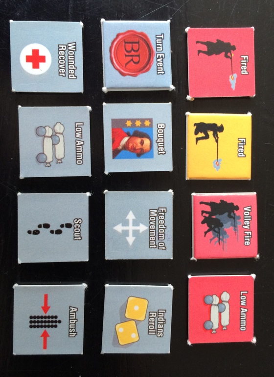
Fire and random turn event markers for MMP’s Battle of Bushy Run

I had a chance to punch and play a new copy of the game this past weekend at Metropolitan Wargamers in Brooklyn, NY. Giving the game it’s first spin with me was a fellow club member who is an instructor at a local college and an expert in 18th-century North American colonial warfare. The playing counters have tidy artwork and are divided into force chips and a variety of other game markers. The British force markers depict the various historic units at the battle with values for strength and movement and step losses. A supply wagon piece provides the path of victory for the British looking to move it off the board and onward to relieve Fort Pitt. Special British scout markers also play as a way to counteract the nature of how the Indian force markers work in the game.

IMG_6386Indian hidden movement map

The Indian force markers display the various tribes present at Bushy Run, and each have an identical strength and movement value. Each also has just one step loss, but the way they work in the game does not reward the Indian player for simply standing to fight against the British. Along with the larger game map where the British column begins fully deployed, the Indians deploy on a smaller hidden map. Throughout the game, the Indian player may move their units from one map to the other as they attack, hide or come back concealed. Additionally, some Indian pieces are dummy markers which can add an additional layer of confusion for the British player struggling to see where their enemy are. These simple markers and the double maps helps to create a fantastic simulation of the challenge of the regular British troops in fighting Indians fading in and out of the woods with harassing attacks. Since movement is by the area, each with it’s own defensive equal for both sides, choosing where and when to fight is important for the British and Indians alike.

IMG_6389
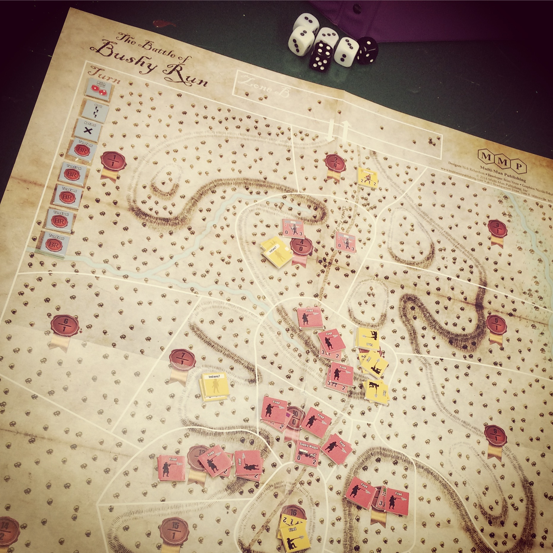
MMP’s The Battle of Bushy Run in progress

Further adding to the unpredictability of the frontier fight is a series of random turn events which can potentially benefit each side in a turn. With the British objective of getting their wagon off the board, the European force must balance choices on when to move, when to engage the surrounding Indian forces and when to stand still to take a round of volley fire. The Indians must capture the wagon using a force which lacks the military superiority of the British, but make up for it in their ability to appear, disappear, move and reappear throughout the battle. Indian casualties can mount quickly under British fire, and the Redcoats can also win by eliminating 14 Indian units.

Our first game resulted in a narrow victory for the British, just wheeling their wagon off the board as the final mass of surviving Indians closed in on all sides. We found the British scouts to be pretty ineffective, but they didn’t hinder the game either. My Indian casualties were high, owing to my more aggressive early game engagement with the British as I worked out how effective the concealed and hidden movement could be. The British also learned some lessons by probably sitting still a turn or two too long, standing and awaiting to fire on the encroaching Indians rather than hustling their column forward from the get-go. For a tiny game depicting a small battle in a largely forgotten period of conflict in Colonial American history, MMP’s The Battle of Bushy Run is a tactical and historical thrill.

The Ratzer Maps At The Brooklyn Historical Society

IMG_5425

Now in its final weeks at the Brooklyn Historical Society, the tiny second floor exhibition Unlocking Two Revolutionary War Maps: The Ratzer Maps at BHS showcases two incredibly important maps of the American War of Independence and the 1776 Battle of Long Island in particular. Alternately known as the Battle of New York and the now-popular Battle of Brooklyn, the Battle of Long Island was the first of the new nation after announcing its independence on July 4, 1776 and the largest of the entire war. For anyone with an interest in the American Revolution or 18th-century New York history, these maps unlock a close-up view of the ground fought over between the British Empire and the upstart Colonials nearly 240 years ago.

IMG_5426The “Percy Map” used during the Battle of Brooklyn in 1776 (left) and the restored 1770 “Ratzer Map” (right) at the Brooklyn Historical Society

Drawn by British cartographer Bernard Ratzer in 1766-1767, the Ratzer Map is one of the seminal documents of early New York. The BHS copy of the full 1770 edition of the Ratzer Map is only one of four in known existence and showcases an early snapshot of Manhattan and nearby Brooklyn in their early days where farms and rural roads still dominated the landscape. The smaller map on display, showing only the lower portion of the Ratzer Map, was carried by British General Hugh Percy during the Battle of Long Island in August 1776. The Percy Map is now co-owned by the BHS and nearby Green-Wood Cemetery, the high ground for much of the battle, and was first put on public view in the summer on 2014 at the cemetery. The current exhibit of these maps at the BHS after a restoration of the full Ratzer map in 2011 is a wonder of 18th-century map making and 21st-century preservation.

schecterbfnyBarnet Schecter’s classic “The Battle For New York” from 2002

The exhibit features text from BHS President Deborah Schwartz and historian Barnet Schecter whose compellingly-detailed The Battle For New York: The City At the Heart Of The American Revolution has become the standard narrative of the battle. Additionally, the BHS has produced a free educational resource entitled Exploring Pre-Revolutionary New York: The Ratzer Map which digs into much of the historical detail found in the map including panoramic views of the shoreline and major landmarks of the era.

History can feel so large and abstract, buried in long ago events which are difficult to square with the present day. The Ratzer Maps at the BHS bring history remarkably into the present and allow a modern viewer to trace pivotal events along lines carefully set down on paper and battlefields more than two centuries ago.

New Game Weekend: Wilderness War

WWbox

I wound up spending a fair amount of time this past year touring sites related to the French and Indian War period while feeding my gamer’s appetite for the Seven Years War period with A Few Acres of Snow. With a little research and talking with some of the members at Metropolitan Wargamers, I decided I needed to go bigger and dive into a game focused on the French and Indian War. All trails led to GMT’s Wilderness War, and I had a chance to play my first game this past weekend.

Published in 2001, Wilderness War is a game that causes a lot of the gamers I know to glaze over with wide grins. The game is designed by Volko Ruhnke and uses a card-driven mechanic much like his COIN games series also published by GMT. I have a few games of the Runke-designed Cuba Libre and Fire In The Lake under my belt, so I knew that a French and Indian War game from him was certain to be a mix of relatively simple rules wrapped up in a rich historic board game experience.

WWboard

Wilderness War game board

The gorgeous map – hardbound in the latest edition – presents the Northeastern colonial areas of North America in the mid 18th-century. As with the war itself, the game is largely defined by geography. “Cultivated” (ie settled) areas are indicated with boxes, and “wilderness” areas and Indian settlements are printed as circles. Mountainous areas are also depicted with chains spreading through western and central Pennsylvania, the Hudson Valley region and portions of central New England. Connecting these areas are roads or trails and the more important waterways which served as the superhighways of the period. Many of the larger cultivated settlements begin with heavy fortresses protecting the space, while the game set up places a series of French and British forts and stockades throughout the map.

wwchips

Sample Wilderness War game counters

Game components consist primarily of 70 cards and 271 cardboard counters. The counters generally depict movement and combat ratings, with reduced values on the flip side once a unit takes damage in battle, during a wintering period or from an event card. Command markers also carry tactics numbers, which help during combat, and a command value. Cards allow activation of units equal to the number printed or by command rating. Special events may also be played for British (red), French (blue) or either side (red/blue), and cards with a brown-red band are events which may be played at any point during either side’s actions.

wwcards

Sample Wilderness War cards

The game plays with year-long turns each containing an early and late season, each approximating about six months of time. In each season, players begin by being dealt eight cards apiece. Later events and actions may modify a player’s hand size, but in general the French and British player then take turns playing cards to move forces, engage in battle, construct defenses or play out events as depicted on the cards. With some pre-planning, each season moves relatively swiftly toward the conclusion of a year of war. At the end of each year, victory points are tallied and units are checked to see if they suffer losses during the winter period between each yearly season of fighting.

Wilderness War comes with a playbook outlining several small to mid-sized games featuring particular periods in the war or a set-up for the entire war from 1755 to 1762. For my first game, we jumped in with both feet and started from the outset of the war  with me playing as the British and my experienced opponent using the French. The French begin the game with a small force stretched across the Lake Ontario, St. Lawrence River and western Pennsylvania regions. British forces start poised on three fronts along the Hudson River, stretching west toward the eastern tip of Lake Ontario at Oswego and just south of western Pennsylvania. The French are buoyed with their strong alliances with several Indian nations while the British hold enormous access to colonial, regular British troops and numerous commanding officers waiting to be called into service.

Using the swift wilderness movement and  raiding capabilities in the 1755 and 1756 turns, the French sent Indian forces into Pennsylvania, Virginia and New England to raid unprotected British cultivated areas. The British quickly moved to redeploy their meager regulars throughout these areas to build stockades and push back further raids. At the same time, the French massed their forces and captured Fort Oswego. By the end of the second year of play, the French were already sitting on six victory points.

With a string of stockaded defenses set up to the west by the beginning of 1757, the British began to land troops at their coastal port arrivals to offset negative British political effects which stymied the use of more Colonial regulars and militia units. British troops commenced the long march into the Pennsylvania mountains and the nearby target French fort at the Ohio Forks (today’s Pittsburgh). Back to the east, the French began using their new base at Oswego to launch a push to the southeast into the Hudson Valley and the ill-defended areas around Albany, Schenectady and the Oneida region. All the while, the French continued to recruit additional Indian forces to buffer their defenses at the Ohio Forks and continue raids toward the east. The 1757 late season ended with my leaving too many British marooned in the mountains of Pennsylvania in a clear rookie mistake which led to my mass of troops taking heavy losses in the winter season.

IMG_4433

The British stockade defenses on the western frontier lay the groundwork for a push on the French at the Ohio Forks in my first game of Wilderness War

By 1758, my British luck seemed to change a bit for the better. Drawing and playing the William Pitt event card, I was able to increase my card hand size to nine cards and gain access to more British forces. Rushing more British reinforcements west into Pennsylvania, the French fell during a siege at the fort protecting the Ohio Forks, giving the British a firm foothold on the western frontier and awarding two victory points. Additional British troops rushed up the Hudson River Valley to hold back the French push toward Albany. As the British remained engaged in fights, the French began shifting their forces along Lake Ontario and the northern frontier while also raising a large force from the Iroquois in central New York. With 1758 at an end, my British forces were safely wintering on two fronts but in a severely weakened state and still way behind on victory points.

We called the game at its midpoint, deciding to restart another time now that I had been introduced to the general game. I still hadn’t experienced some major facets of the game such as naval movement and amphibious warfare, but I had quickly come to understand some of the major drivers of how the game plays. As a beginner, here are some lessons learned from my first game of Wilderness War:

  1. Defend the frontier. Especially for the British, but for both players, keeping the frontier defended by building stockades and forts is a must. Regular troops caught in wilderness areas are easy targets for Indians and other non-regulars, so having defenses built is key to defending territory. Having a network of stockades and forts to defend from, retreat to and maintain supply line coherence is a necessity if an army is going to succeed in the wilds of North America.
  2. Don’t get caught out in the cold. Open country and mountains are a strong enemy, particularly to 18th-century European armies. Paying attention to stacking limits as each year ends is important to keeping a force at strength. When conducting operations, players need to keep in mind where their troops will all wind up as a year ends and forces settle in for the winter. Nothing is worse than spending a series of turns marching troops into position only to have a portion of them die from starvation, disease and exposure in the period following each year’s turn.
  3. Play the long game. The full game goes to eight years of warfare, so strategy needs to take a long view. The first half of the game most probably belongs to the French as they and their Indian allies sack the wide open and undefended frontier. The British simply can’t be everywhere in the early years of the war, so spending time building defenses while also waiting to get the right cards to call in reinforcements is important. Massing and moving large forces on both sides to be strong enough to siege and capture forts takes a fair amount of planning but pays off in victory points.

Wilderness War is a fantastic playable document of the French and Indian War. The shifting alliances, opportunistic events, geography of the country itself intertwine to capture the period with a realness that might be familiar to any French or British commander on the 18th-century American frontier.

ww logo

Touring French and Indian War America

FIWeramap

In the spring and summer of this year I vacationed in Missouri, Western New York and Southwestern Pennsylvania. While visiting family and friends was the main focus of my trips, my journeys intersected with the French and Indian War period repeatedly while driving hundreds of miles of back roads throughout the Northeast and Midwest. The hilly regions of the East were  formative in the first half of my life and the flat plains of the Mississippi River have been a presence in the past twenty years after marrying my wife from Missouri.

FIWsites

National Park Service map with French and Indian War era sites I’ve visited

These regions also played a large role in the origin story of what would become the United States of America. The 18th-century American continent was the New World front in the worldwide competition between the French and English for worldwide colonial control. In the Americas, native peoples were inserted into the European conflict with the various Indian Nations shifting alliances among the European powers.

From 1754-1763, the Seven Years War stretched around the globe and occupied the colonial regions of America with the French and Indian War. From the Great Lakes and mountains of Upstate New York to the Allegheny Highlands of Pennsylvania to the western rivers frontier, French, British, Native American and American colonists fought for the future of the what would become the modern United States and Canada.

Over the years, I’ve had occasion to visit numerous sites from this contested Anglo-French period. Family day trips when I was a kid took me to just about every major fort and battlefield in New York state and nearby Canada, including Fort Niagara, Fort Ontario, Fort William Henry, Fort Ticonderoga and Fort York at present day Toronto. During graduate school in Michigan, I spent a weekend at the northern tip of the state and visited Fort Michilimackinac. After graduate school, my time in Pennsylvania included visits to Fort Ligonier, Fort Necessity and the site of Fort Duquesne at Pittsburgh. Since meeting my future wife while in Pennsylvania, I’ve spent a fair amount of time in Missouri, getting married in the historic French town of St. Charles and visiting other colonial era towns and sites.

With the French and Indian War on my gaming mind this past year with the excellent A Few Acres of Snow, here’s a few of the places I’ve managed to visit (or revisit) this past year.

French Settlements on the American Western Colonial Frontier

Over the Easter weekend, I visited my in-laws in St. Louis and St. Charles, Missouri. After a bit of time in and around St. Louis, we headed south along the Mississippi River to Ste. Genevieve. Settled in the 1730s, Ste. Genevieve showcases a remarkably intact collection of distinctive French colonial-influenced buildings. We were particularly fortunate in being allowed to walk through the Bequette-Ribault House which I had read about in one of my graduate school classes. The building was under renovation, allowing us to view a rare surviving example of the “poteaux en terre” construction technique of posts sunk vertically into the ground.

From Ste. Genevieve we took a rickety ferry across the Mississippi and drove along the Illinois side to Fort des Chartres. Reconstructed in the 1930s, the fort today depicts a French outpost way out on the western boundaries of claims to French territory in the 18th-century which stretched from Canada to New Orleans. Standing in the middle of hundreds of miles of farmland all around, it’s amazing to imagine a small garrison of French soldiers at the fort watching over the far edges of a European empire over nearly 300 years ago. The well-interpretted partial reconstruction of the fort itself and the small on site museum captures the scope of the French empire’s commitment to taking a territorial stand on this edge of the New World.

Although the French would cede much control of North America to the British after the end of the French and Indian War, evidence of French culture remains in buildings and place names throughout the old colonial areas. Visitors from France and French-speaking Canada still flock to Ste. Genevieve and the surrounding area every year, and walking the streets of the town and the battlements of Fort des Chartres the French legacy still echoes today.

10261977_10202979904952968_8594578130842737852_n

Statue of King Louis IX of France, at the Saint Louis Art Museum

1526266_10202966521378387_8592928619118650316_n[1]

The Bolduc House (c. 1770)  in Ste Genevieve, Missouri

10150539_10202966523138431_7971748547386340404_n

The Bequette-Ribault House (c. 1780) in Ste Genevieve, Missouri

10294434_10202966516098255_2984079262433725022_n[1]

Fort de Chartres (c. 1720) near Prairie du Rocher, Illinois

Mary Jeminson, “The White Indian of the Genesee”

This summer I also took my family back to my hometown in Western New York which sits a quick drive from Letchworth State Park, home to deep river-cut gorges and spectacular waterfalls. The park also celebrates the story of Mary Jeminson, a young girl who was abducted from her family’s Eastern Pennsylvania farm in 1755, traded to Seneca Indians near Fort Duquesne and lived the remainder of her long life as a prominent member of the Iroquois in the area around present day Letchworth.

The legendary story of Jeminson is remarkable, and her life tells the story of the complicated territorial and military alliances between the various Native American and European peoples in the French and Indian War and subsequent American War of Independence. Jeminson is remembered at Letchworth with a monument marking where her remains were relocated in 1872 adjacent to a Seneca Council House which interprets the native people’s governance of the region during the colonial and post-Revolution period.
IMG_3946

The Mary Jeminson Monument at Letchworth State Park

IMG_3951

Seneca Council House relocated to Letchworth State Park in 1872

The National Road and Fort Necessity National Battlefield

Twenty years ago this summer I served as an intern researching and writing National Register of Historic Places nominations for three historic pike towns along the National Road (Route 40) in Pennsylvania. I hadn’t travelled back to the region in two decades, and touring Route 40 again brought back to me how rich the area is in early colonial American history.

Fort Necessity National Battlefield interprets a pivotal series of events that took place in this corner of the Pennsylvania wilderness in 1754 and 1755, arguably leading to the eruption and eventual escalation of the French and Indian War in North America. Commanding a force of Virginia colonial militiamen, British Lt. Col. George Washington encountered a small detachment of French Canadiens led by Joseph Coulon de Villiers de Jumonville in May 1754. After a brief firefight, Jumonville was killed by Anglo-allied Mingo warriors. Two months later, a large force of French, Canadiens and Indians led by Jumonville’s brother Louis Coulon de Villiers met Washington’s small group in a wet, open meadow. Washington hastily built a stockade – a “fort of necessity” – but was overwhelmed by the French force attacking from the woods in a driving rain. One year later, Washington’s mentor General Edward Braddock met his end nearby during his doomed attempt to lad a British force inland to seize the French Fort Duquesne.

In the years since I’ve been to the battlefield, the National Park Service has created a new, modern visitors center telling two important stories from the past. The French and Indian War and its beginnings in the area nearby is depicted through interactive maps, videos and some great exhibits that zero in on the individual nations who fought over the region over two hundred years ago. The construction of the nearby National Road in the decades after the conflict occupies second half of the museum’s narrative, depicting the importance it played in the push West and economic development of the new nation in the early 19th-century. By the time you’ve spent a couple of hours in the visitors center and exploring the hilly region, you can’t help but leave with a real sense of the massive importance this part of Western Pennsylvania played in setting the stage for American progress in the subsequent decades.

IMG_3945

Fort Necessity National Battlefield

As with most of the French and Indian War and Anglo-French colonial era sites I’ve visited, it is remarkable that such wide-reaching ripple effects through centuries of subsequent history took place in these tiny corners of what was then an open territory for Europeans and home to a rich culture of Native peoples. By the end of the French and Indian War, the British had laid claim to much of the Americas. In so doing, the seeds of descent had also been sown among a bitter population of American colonists who would eventually rise up in independence against their British rulers.

All my travel this past year, followed up by a rewatching of the PBS series The War That Made America, has definitely fuelled the French and Indian War bug in me. I’ve put a few books on my reading list, including Fred Anderson’s Crucible of War, and Richard Berleth’s Bloody Mohawk. The period has also led me to pick up Wilderness War from GMT Games, the modern go-to board game on the period. With more than two-and-a-half-centuries between today and the fight for empire in the Americas, the French and Indian War is very much alive for me.

New York Harbor Defense History and Civil War Weekend at Governors Island

CastlewilliamsgiShuttling back and forth between Brooklyn and Manhattan every day on the New York City subway system, it’s sometimes easy to forget I live and work in area surrounded by coasts. This past weekend I hopped a free mid-morning ferry from Brooklyn to Governors Island National Monument for some immersion in NYC’s coastal defense history and annual Civil War Weekend sponsored by the National Park Service.

New York Harbor Defense History

From the beginning of European settlement of New Amsterdam on the island of Manhattan by the Dutch in the early 1600s, the importance of New York Harbor as a gateway to a system of  trade and military defense was clear. The Dutch colony’s main defense at Fort Amsterdam eventually ceded to the British who maintained fortifications on the spot until after the American Revolution. In the post-Revolution centuries, the defense of New York Harbor remained a focus of the US military against foreign and domestic would-be aggressors.

Governorsislandplan1908 US Army Corps of Engineers map of Governors Island with Fort Jay (center) and Castle Williams (left)

Governors Island offers a good historic overview of the development of New York’s coastal defense works from the 18th through 19th centuries. Fort Jay dates from the late 18th-century when American colonists and British troops exchanged control of the island with various earlier wood and earth forts. The existing facility is a classic European-style star fort with masonry and earthen walls is typical of the design built all over the world from the 15th through 19th centuries. Entering through elaborate gates, a visitor walks into a peacefully idyllic central courtyard surrounded by Greek Revival colonnaded buildings with welcoming porches. Several cast iron Civil War era 10 and 15 inch Rodman cannons survive on the fort’s walls, pointing toward the harbor.

IMG_4073Guns overlook New York Harbor from Fort Jay

The later Castle Williams was built between 1807 and 1811 as a fortification just ahead of the War of 1812. The state-of-the art, circular casemate sandstone pile was designed by Col. Jonathan Williams, at the time the chief of the US Army Corps of Engineers. The first fort designed by an American engineer, Castle Williams presents three tiers of gun ports from which a nearly 360-degree field of defensive fire across the harbor.

IMG_4074The imposing walls of Castle Williams

Together with Fort Wadsworth on Staten Island, Fort Wood (today the base of the Statue of Liberty on Liberty Island), Castle Clinton at the southern tip of Manhattan and Fort Gibson at today’s Ellis Island, Fort Jay and Castle Williams served as part of the interlacing network of forts protecting New York Harbor through the 19th-century. Both Fort Jay and Castle Williams would go on to other roles as the site of a Confederate prisoner of war camp during the Civil War, a US Army prison in the middle of the 20th-century and the site of a large US Coast Guard base until closing in 1996. Gone is the military use of Governors Island today, but the spaces still serve the public as place to walk amid important and usually unseen history of New York.

Civil War Weekend

Each August the National Park Service presents the only Civil War encampment of reenactors in New York City. With about a dozen tents in a small camp and more than twenty staff and volunteer reenanctors, the weekend’s events gives New Yorkers an up-close glimpse of a solder’s life during the Civil War.

IMG_4068Reenactors encamped at Governors Island

IMG_4076A Civil War era soldier’s equipment sits at the ready in camp

IMG_4072A reenactor discusses a Civil War soldier’s life with visitors to Governors Island

IMG_4075An officer reenactor speaks with with visitors to Governors Island

Aside from an opportunity to speak with reenactors and view some typical soldier’s equipment and life in camp, demonstrations of canon firing, drilling and infantry weapons are presented. For the less militarily-minded, period music was also offered in the comfort of shaded grass and rocking chairs inside the walls of Fort Jay.

IMG_4069Officer inspection of the troops at Governors Island

IMG_4070Canon firing demonstration during Civil war Weekend at Governors Island

IMG_4071Civil War era cannon shot, canister and ordinance loads

Although the use of Governors Island has primarily been military for several centuries, visiting the island today serves up multiple experiences. While the historic forts and sites under the governance of the National Park Service occupy approximately 22 acres to the north, the remaining 150 acres is now overseen by the Trust for Governors Island. The Trust has worked to create an oasis of recreational areas for picnicking, play, bike riding, strolling and relaxing among historic buildings, allays of trees, wide grassy lawns, outdoor sculpture and newly designed landscapes. Whether you are a visitor looking for a step back into American history or just unwind from the city’s usual hustle, Governors Island can give a whole new perspective on New York at the center of the harbor and world.

New Game Weekend: A Few Acres of Snow

AFewAcrescover

 “You know that these two nations are at war about a few acres of snow somewhere around Canada, and that they are spending on this beautiful war more than all Canada is worth.” — Voltaire, Candide (1758)

In the 17th and 18th centuries, the area of what would become the Northeastern United States and the neighboring Canadian Provinces of Ontario and Quebec were a battlefield for French, British and Native American control. With the two European empires locked in a protracted series of large and small wars around the globe, the American colonies were often a sideshow to the global conflict. In the colonies, King William’s War (1689–97), Queen Anne’s War (1702-13), King George’s War (1744–48) and the French and Indian War (1754–63) each played a role in shaping not only the birth of the United States of America but also the face of the entire globe for centuries to come.

Colonies

A mid-18th century map of British and French colonies in North America

(from New York Public Library Map Division)

I grew up in Western New York State, spent most of my twenties in Eastern Michigan and Western Pennsylvania, and finally settled in New York City nearly twenty years ago. In my life I’ve logged many a road trip to the landmarks of British and French military control at Fort Stanwix, Fort Ticonderoga, Fort William Henry and Fort Niagara, along with various battlefields and stops at roadside markers. In July, I’ll be swinging by Fort Necessity in Pennsylvania where a British officer named George Washington first commanded troops in an opening battle of the French and Indian War. I’ll also be swinging through Letchworth State Park which was occupied by the western edges of the Iroquois Confederacy which sided with the British during the era of European conflict. In short, I’ve spent my entire life living amid the ghosts of the contested colonial regions of the North American colonial wars.

AcresCardsSample cards from A Few Acres of Snow

At the recent D-Day Plus 70 weekend at Metropolitan Wargamers in Brooklyn, NY I was fortunate to score a copy of A Few Acres of Snow in a dice-off raffle. Created by famed designer Martin Wallace and released by Treefrog Games in 2011, the game takes its name from a quote from Voltaire’s Candide commenting on the absurdity of European focus on colonial wars for territory. AFAOS takes players through the French-British colonial period in North America as each nation competed for control of the continent. Within the theme, the game is a rich mix of deck-building and area control mechanics as players seek to settle and defend key areas of the map.

snowsymbolsCard symbols from A Few Acres of Snow

(Wagon, Bateaux, Settler, Military Strength, Money, Fur, Ambush and Ship)

The two-player game begins with players choosing a side as the British or French with a set number of settled outposts in the wilderness of 17th and 18th century North America. British begin with their main settlements in New York and Boston while the French player starts with Quebec. Players begin with a draw deck from which they start with five cards. Playing cards in turns of two actions each, players perform a variety of actions including settlement, fortification, raids, sieges, trade, piracy and a number of card management options. Symbols depicted on each card allow for enormous flexibility in how each player executes their strategy of expansion. For example, a player might begin with a Location card setting off from an existing settlement. From there, a card is played with the appropriate movement symbol like a Bateaux along a river. Once at a new location, a card with a Settler might be played to create a new settlement. As a player’s holdings expand, their decks grow in size and options, leading to even more potential paths of empire growth. Once all settlement tokens are used or major settlements like Boston or Quebec are captured, the games ends and victory points are scored.

IMG_3640My first play of A Few Acres of Snow

In my first play through AFAOS, I faced off with my son playing the French and me playing as the British. The game plays in about an hour, but on our first run we went to a bit over 90 minutes as we wrapped our heads around the rules. After I quickly sailed to and settled Halifax well within the bounds of French country, several  sieges commenced. In his first siege attempt, my son was repelled by my superior military might powered by my store of money. He then took a few turns to quickly trade a lot of fur (one of the strengths of the French player) to buy additional forces for a second siege which chased my British from his territory.

IMG_3647My heavily-settled British Atlantic Coast in A Few Acres of Snow

In the meantime, I pushed inland with a string a settlements toward the Great Lakes in the hopes it would expose Quebec to a siege. However, my son quickly landed a stronghold in my coastal territory in a siege victory at Pemaquid. I retaliated with two failed attacks on Pemaquid using Native American raiding parties. Having held on, my son launched an attack on Boston and my British rule of the colonies fell.

Our first game showed us how quickly AFAOS can move once you get the mechanics. Getting the right cards in and out of your hand is key to winning the game, and the cards shift in importance as the game quickly unfolds. The balance of trade, expansion and military actions does a fantastic job in re-enacting the dynamics which played out between the British, French and shifting Native American allies over some 150 years. Even though we upset the course of history, we both walked away pretty thrilled over our new game and chatting up strategies for the next time we meet up in the woods and along the coasts of Colonial America.

afaosart

Downloading: Blogging War In Pictures

11290985505_26680f4f03_c

I’ve made my living for the past 17 years in the pictures business. In 1996, I arrived in New York City and landed a job with a photo-licensing company doing historic photo research. My days were spent fulfilling client requests for photos, illustrations and artwork to be used in advertising, corporate marketing, book publishing, magazines and newspapers,  documentaries, motion pictures and TV programming. Since then, I’ve gone on to work with several of the largest stock photo and film licensing companies in the world.

In my time, I’ve participated in the rapid changes in the business as it evolved from a world of photo prints kept in dusty file cabinets to the digital marketplace of images today. The proliferation of online search and digital photography databases has granted professionals and non-professionals alike enormous access to visuals illustrating  the arc of world history from the dawn of time to the latest celebrity gossip.

With this has come the significant challenges of copyright management. Companies like those that have employed me license images for a fee ranging from a couple bucks to tens-of-thousands of dollars each, depending on the use and value of the image (often based on murky concepts of scarcity and quality). With these licensing fees, photographers, archives recieve payment and people like me are able to pay the rent and feed my kids.

With images easily available online there is a lot of misinformation on in what instances a photo which may be used without paying someone a fee. Bloggers and other online outlets (and even traditional print-based users) regularly use photos under misunderstood concepts like “fair use.” In short, unless someone is granting you permission to use their works you could very well be in some sort of copyright violation and subject to significant legal and financial penalties. This is a conversation we in the licensing business have countless times a day with new and old customers alike.

For a blogger like me, I try to take as many photos myself and stick to others that are either out of copyright or used in the context of reviewing a game, book or film. Looking for great historical reference images for use online or off still remains a challenge at times, but it keeps getting easier all the time.

This past week, the British Library announced the release of nearly one million images for free use via Flickr Commons. The BL becomes the latest insitutional archive to make available enormous selections of images. For bloggers, gamers and armchair historians, these resources are incredible and hours can be spent paging through them. Other existing collections of interest for wargamers include:

For now, below is just a taste of what’s new to be found in the British Library’s new online Flickr collection. The emphasis is on 18th-19th century history with tons of maps, engravings, diagrams and photographs. The Napoleonic Wars is documented in a ton of gorgeous color plates of uniformed soldiers, making them a perfect reference for your miniatures painting projects. The American Civil War is represented in scores of maps, portraits of various military and political leaders and lots of reference drawings of equipment and fortifications. The centuries of Britain’s colonialism is captured with a lot of material on Egypt, South Africa and the Middle East. Finally, there is a fair amount of naval and land imagery from the Spanish-American War.

Have a look for yourself and I’m sure you’ll find some obscure visual historic treasure of your own.

Napoleonic Wars

11197448323_f29a6f55fa_c

11003362935_ac6bd93346_c

11003528116_3ec187b941_c

American Civil War

11189959606_caa7577d01_c

11195430764_c3203d4309_c

11203099085_144b616820_c

11187451524_41b1288915_c

African Colonial Wars

11213541216_3036b5474e_c

11034541986_c31dcfcff5_c

11235101336_f9af33fc5b_c

Spanish-American War

11244813946_7135b5594b_c

santiago

11244838355_a6551da621_c